| Dam/Weir: URUMI I | |||
| Location | Latitude:11⁰22’51.85”N Longitude:76⁰3’41”E | Dam Features | |
| Type of Dam | Concrete gravity | ||
| Panchayath | Koodaranji | Classification | Weir |
| Village | Koodaranji | Maximum Water Level (MWL) | EL 212.1 m |
| District | Kozhikode | Full Reservoir Level ( FRL) | EL 212.1 m |
| River Basin | Chaliyar | Storage at FRL | Diversion only |
| River | Poyilingalpuzha | Height from deepest foundation | 5.6m |
| Release from Dam to river | Poyilingalpuzha | Length | 47.0 m |
| Taluk through which release flows | Thamarassery | Spillway | Overflow section |
| Year of completion | 2004 | Crest Level | EL 212.1 m |
| Name of Project | Urumi stage I SHEP | River Outlet | 1 No. flushing sluice |
| Purpose of Project | Hydro Power- Runn off | Officers in charge & phone No. | Executive Engineer, KG Division, Kakkayam, PIN-673615 Phone.9446008466 |
| Installed capacity of the Project | 3×1.25 ( 3.75 Mw) | Assistant Executive Engineer, SHEP,Kakkayam, PIN- 673615 Phone.9446045170 | |
| Project Identification Code ( PIC) | Nil | ||
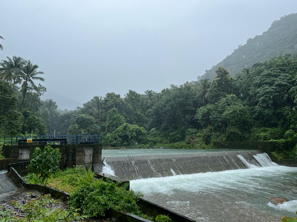
| This weir is constructed for power generation in a Small Hydro Electric Project. The weir is constructed across the Poylingalpuzha which is tributary of Chaliyar river, Location is at Urumi near Poovaranthodu, Koodaranji village of Kozhikode district. |

URUMI 1| Dam/Weir: URUMI II | |||
| Location | Latitude:11⁰22’22”N Longitude:76⁰3’30.4”E | Dam Features | |
| Type of Dam | Diversion weir | ||
| Panchayath | Thiruvambady | Classification | Weir |
| Village | Thiruvambady | Maximum Water Level (MWL) | EL 107.1 m |
| District | Kozhikode | Full Reservoir Level ( FRL) | EL 107.1 m |
| River Basin | Chaliyar | Storage at FRL | Diversion only |
| River | Poyilingalpuzha | Height from deepest foundation | 5.6m |
| Release from Dam to river | Poyilingalpuzha | Length | 25.0 m |
| Taluk through which release flows | Thamarassery | Spillway | Not provided |
| Year of completion | 2004 | Crest Level | EL 107.1 m |
| Name of Project | UrumiSHEP Stage II | River Outlet | |
| Purpose of Project | Hydro Power | Officers in charge & phone No. | Executive Engineer, KG Division, Kakkayam, PIN-673615 Phone.9446008466 |
| Installed capacity of the Project | 3 x 0.8 Mw | Assistant Executive Engineer, SHEP, Kakkayam, PIN- 673615 Phone:9446045170 | |
| Project Identification Code ( PIC) | Nil | ||
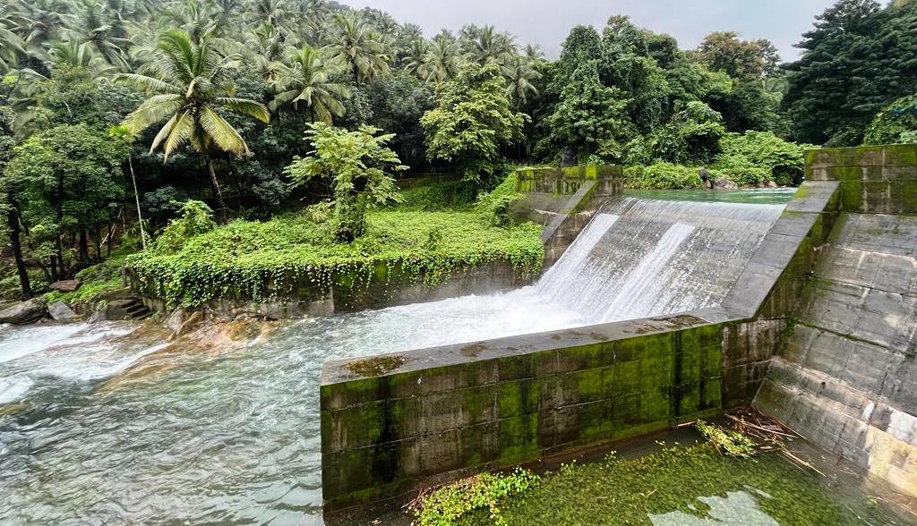
| A weir is constructed across the Poyilingalpuzha river, downstream of Urumi I power house to divert water to Urumi II power house. This is located in Thiruvambady , 50 Km away from Kozhikode town. The water from the reservoir is drawn to the Power House through a power channel 470 m long. |

URUMI II| Dam/Weir: CHEMBUKKADAVU I | |||
| Location | Latitude:11⁰28’13.5”N Longitude:76⁰2’46.9”E | Dam Features | |
| Type of Dam | RCC lining over a RR core structure | ||
| Panchayath | Kodenchery | Classification | Weir |
| Village | Kodenchery | Maximum Water Level (MWL) | EL 302.9 m |
| District | Kozhikode | Full Reservoir Level ( FRL) | EL 302.9 m |
| River Basin | Chaliyar | Storage at FRL | Diversion only |
| River | Chalipuzha | Height from deepest foundation | 6.5 m |
| Release from Dam to river | Chalipuzha | Length | 35.50 m |
| Taluk through which release flows | Thamarassery | Spillway | No spillway |
| Year of completion | 2003 | Crest Level | EL 302.9 m |
| Name of Project | Kuttiady Augmentation Scheme | River Outlet | Nil |
| Purpose of Project | Hydro Power | Officers in charge & phone No. | Executive Engineer, KG Division, Kakkayam, PIN-673615 Phone.9446008466 |
| Installed capacity of the Project | 3×0.9(2.7Mw) | Assistant Executive Engineer, Civil Maintenance Sub Division, Kakkayam , PIN-673615 Phone.9496012190 | |
| Project Identification Code ( PIC) | Nil | ||
| The location of the scheme is at Chembukadavu near Tusharagiri in Kodencherry village of Kozhikode district. It is 55 Km away from Kozhikode town. The weir is constructed across Chalipuzha river. |

Chempukadavu| Dam/Weir: POOZHITHODU | |||
| Location | Latitude:11⁰39’4.5”N Longitude:75⁰51’47.5”E | Dam Features | |
| Type of Dam | Concrete gravity | ||
| Panchayath | Kavilumpara | Classification | Weir |
| Village | Maruthomkara | Maximum Water Level (MWL) | EL 272.6 m |
| District | Kozhikode | Full Reservoir Level ( FRL) | EL 271.35 m |
| River Basin | Kuttiady | Storage at FRL | Diversion only |
| River | Illianipuzha & Kadanthrapuzha | Height from deepest foundation | 6.0 m |
| Release from Dam to river | Kadanthra puzha | Length | 56.95 m |
| Taluk through which release flows | Koyilandy | Spillway | No spillway |
| Year of completion | 2011 | Crest Level | EL 271.35 m |
| Name of Project | Poozhithode Small Hydro Electric Project | River Outlet | |
| Purpose of Project | Hydro Power | Officers in charge & phone No. | Executive Engineer, KG Division, Kakkayam, PIN-673615 Phone.9446008466 |
| Installed capacity of the Project | 3×1.6(4.8Mw) | Assistant Executive Engineer, SHEP,Kakkayam, PIN- 673615 Phone.9446045170 | |
| Project Identification Code ( PIC) | Nil | ||
| This project is a run – off the river scheme utilizing water from Illiani puzha and Kadanthra puzha . It is 61 Km away from Kozhikode and near to Perambra town.The weir is constructed across Kadanthrapuzha . |

Poozhithode| Dam/Weir: PANOTH(Vilangadu SHEP) | |||
| Locatio | Latitude:11⁰46’36.6”N Longitude:75⁰47’9.74”E | Dam Features | |
| Type of Dam | Concrete gravity | ||
| Panchayath | Naripatta | Classification | Weir |
| Village | Vilangad | Maximum Water Level (MWL) | EL 186.33 m |
| District | Kozhikode | Full Reservoir Level ( FRL) | EL 185.05 m |
| River Basin | Vaniyam | Storage at FRL | Diversion only |
| River | Mahe puzha | Height from deepest foundation | 8.55m |
| Release from Dam to river | Mahe puzha | Length | 44.5m |
| Taluk through which release flows | Vadakara | Spillway | 2 Nos. 1.50 x 1.30 m |
| Year of completion | 2014 | Crest Level | EL 185.05m |
| Name of Project | Vilangad Small Hydro Electric Project | River Outlet | 1 No. sluice gate |
| Purpose of Project | Hydro Power | Officers in charge & phone No. | Executive Engineer, KG Division, Kakkayam, PIN-673615 Phone.9446008466 |
| Installed capacity of the Project | 7.5 MW | Assistant Executive Engineer, SHEP,Kakkayam, PIN- 673615 Phone.9446045170 | |
| Project Identification Code ( PIC) | Nil | ||
| It is the second weir of Vilangad SHEP. It is located at Panoth near Vilangad in Vadakara taluk of Kozhikode district. |

Panoth| Dam/Weir: VALOOK(Vilangad) | |||
| Location | Latitude:11⁰45’36.5”N Longitude:75⁰46’32.5”E | Dam Features | |
| Type of Dam | Concrete gravity | ||
| Panchayath | Naripatta | Classification | weir |
| Village | Thinur | Maximum Water Level (MWL) | EL 184.96 m |
| District | Kozhikode | Full Reservoir Level ( FRL) | EL 183.90 m |
| River Basin | Mahe puzha | Storage at FRL | Diversion only |
| River | Kavadi puzha | Height from deepest foundation | 7.90m |
| Release from Dam to river | Mahe puzha | Length | 45.95m |
| Taluk through which release flows | Vadakara | Spillway | 2 Nos. 1.50 x 1.30 m |
| Year of completion | 2014 | Crest Level | EL 183.90 m |
| Name of Project | Vilangad Small Hydro Electric Project | River Outlet | NIL |
| Purpose of Project | Hydro Power | Officers in charge & phone No. | Executive Engineer, KG Division, Kakkayam, PIN-673615 Phone.9446008466 |
| Installed capacity of the Project | 7.5 MW | Assistant Executive Engineer, SHEP,Kakkayam, PIN- 673615 Phone.9446045170 | |
| Project Identification Code ( PIC) | Nil | ||
| It is one of the two weirs of Vilangad SHEP. It is located 85 Km away from Kozhikode town. It is a run- off the river scheme utilizing water of Vaniyampuzha and Kavadipuzha. |
| Dam/Weir: KARINGAD (CHATHANKOTTUNADA) | |||
| Location | Latitude : 11⁰ 41′ 45.63 ” N | Dam Features | |
| Longitude: 75⁰ 46′ 53.53” E | Type of Dam | Concrete – gravity | |
| Panchayath | Kavilumpara | Classification | Weir |
| Village | Maximum Water Level (MWL) | EL 127.93 m | |
| District | Kozhikkode | Full Reservoir Level ( FRL) | EL 126.60 m |
| River Basin | Kuttiyadi | Storage at FRL | Diversion only |
| River | Karingad (Tributory of Kuttiady river) | Height from deepest foundation | 10.43m from deepest Foundation, 7.93m from Bed Level |
| Release from Dam to river | Kuttiyadi | Length | 50.64 m |
| Taluk through which release flows | Vadakara | Spillway | overflow section |
| Year of completion | 2020 February | Crest Level | EL 126.60 m |
| Name of Project | Chathankottunada Small Hydro Electric Project | River Outlet | 1 No 1.00×1.00, sofit level-125.00, Sill level 124.00 |
| Purpose of Project | Hydro Power | Officers in charge & phone No. | Executive Engineer, Generation Division, Kozhikode Mob:- 9446008476 |
| Installed capacity of the Project | 6 MW | Assistant Executive Engineer Generation Sub Division, Kozhikode Phone – 9496001716 | |
| Project Identification Code ( PIC) | Nil | ||
| This weir is a part of Chathankottunada SHEP, which envisages development of power by utilizing the potential of Karingad and poothampara sreams- tributaries of Kuttiyadi River. It consist of two diversion weirs( at Karingad and Poothampara), two power channels of 1448 m and 2155m, common forebay , penstock of 240 m long and a Surface Power House of 6 MW capacity(2×3 MW). |
| Dam/Weir: POOTHAMPARA (CHATHANKOTTUNADA) | |||
| Location | Latitude : 11⁰ 41′ 57.02 ” N | Dam Features | |
| Longitude: 75⁰ 47′ 53.70” E | Type of Dam | Concrete – gravity | |
| Panchayath | Kavilumpara | Classification | Weir |
| Village | Maximum Water Level (MWL) | EL 127.50 m | |
| District | Kozhikkode | Full Reservoir Level ( FRL) | EL 126.60 m |
| River Basin | Kuttiyadi | Storage at FRL | Diversion only |
| River | Poothampara(Tributory of Kuttiady river) | Height from deepest foundation | 6.5 m ( above normal bed level), 10.8m from deepest Foundation |
| Release from Dam to river | Kuttiyadi | Length | 54.7 m |
| Taluk through which release flows | Vadakara | Spillway | overflow section |
| Year of completion | 2020 February | Crest Level | EL 126.60 m |
| Name of Project | Chathankottunada Small Hydro Electric Project | River Outlet | 1 No 1.00×1.00, sofit level-124.65, Sill level 123.65 |
| Purpose of Project | Hydro Power | Officers in charge & phone No. | Executive Engineer, Generation Division, Kozhikode, Mob:-9446008476 |
| Installed capacity of the Project | 6 MW | Assistant Executive Engineer Generation Sub Division, Kozhikode Phone – 9496001716 | |
| Project Identification Code ( PIC) | Nil | ||
| This weir is a part of Chathankottunada SHEP, which envisages development of power by utilizing the potential of Karingad and poothampara sreams- tributaries of Kuttiyadi River. It consist of two diversion weirs( at Karingad and Poothampara), two power channels of 1448 m and 2155m, common forebay , penstock of 240 m long and a Surface Power House of 6 MW capacity(2×3 MW). |